- Reference
- Proc.Linn.Soc.New South Wales 85:348 (1961)
- Conservation Code
- Not threatened
- Naturalised Status
- Native to Western Australia
- Name Status
- Current
Rhizomatous, usually tufted proliferous perennial, grass-like or herb, 0.15-0.35 m high, to 0.5 m wide. Fl. yellow, Sep to Oct. White or yellow sand, clayey loam. Winter-wet situations.
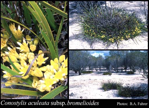
Scientific Description
Leaves flat, 90-300 mm long, 3-6 mm wide; bristles or hairs on the leaf margin present, 2.2-4.5 mm long, straight and rigid, diverging outward at around 90°; hairs on the surface of the leaf absent (leaf surfaces glabrous). Scape present, hairy, 55-70 mm long. Inflorescence subtended by a bract 6-12 mm long, with several flowers; floral bracts 5-7 mm long; pedicels present, 1.5-3 mm long; flowers 11-18 mm long. Perianth hairy, radially symmetrical, uniformly coloured, yellow, with six more or less equal tepals, the inner segments 6.5-8.5 mm long. Stamens six, in one level; filaments 0.5-1.5 mm long; anther 4-4.5 mm long, without an appendage. Style 9.5-10 mm long. Flowers in September or October. Occurs in the Geraldton Sandplains, Swan Coastal Plain, Avon Wheatbelt, Jarrah Forest and Mallee IBRA bioregion(s), of the South-west Botanical Province.
Distribution
- IBRA Regions
- Avon Wheatbelt, Geraldton Sandplains, Jarrah Forest, Mallee, Swan Coastal Plain.
- IBRA Subregions
- Dandaragan Plateau, Katanning, Lesueur Sandplain, Merredin, Northern Jarrah Forest, Perth, Southern Jarrah Forest, Western Mallee.
- Local Government Areas (LGAs)
- Beverley, Carnamah, Chittering, Coorow, Cunderdin, Dalwallinu, Dandaragan, Gingin, Goomalling, Lake Grace, Moora, Mundaring, Narembeen, Narrogin, Swan, Tammin, Wagin, Wanneroo, West Arthur, Wongan-Ballidu, Wyalkatchem, York.