- Conservation Code
- Not threatened
- Naturalised Status
- Native to Western Australia
- Name Status
- Current
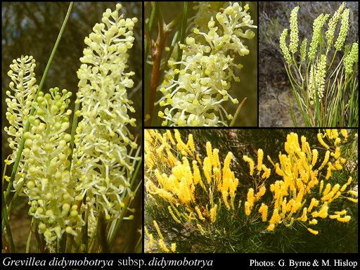
Erect shrub, (0.3-)1-3(-5) m high, leaves subterete to linear. Fl. yellow-green/cream, Feb to Mar or Jun to Dec. Yellow, red orange-brown sand, gravel. Sandplains.
Scientific Description
Shrubs, 1-3 m high; branchlets hairy, not glaucous. Leaves alternate, 30-120 mm long, 1-3 mm wide, hairy, on the adaxial or abaxial surface, the hairs straight; lamina subterete, entire, the margins flat. Inflorescences terminal, cream or yellow; pedicels 1-4 mm long. Perianth 3-4 mm long; tepals all free after flower opens, hairy, simple-hairy; ovary glabrous, stipitate, the stipe 0.2-0.5 mm long; pistil 4-6 mm long, cream or yellow, pollen presenter conical, style glabrous. Follicles glabrous, not viscid, dehiscent, 5-8.5 mm long. Flowers in January, August, September, October, November or December. Occurs in the Eremaean (ER) or South-west (SW) Botanical Province(s), in the Carnarvon (CAR), Yalgoo (YAL), Murchison (MUR), Great Victoria Desert (GVD), Coolgardie (COO), Swan Coastal Plain (SWA), Avon Wheatbelt (AW), Mallee (MAL) or Esperance Plains (ESP) IBRA subregion(s).
Distribution
- IBRA Regions
- Avon Wheatbelt, Carnarvon, Coolgardie, Esperance Plains, Geraldton Sandplains, Great Victoria Desert, Mallee, Murchison, Nullarbor, Yalgoo.
- IBRA Subregions
- Carlisle, Eastern Goldfield, Eastern Mallee, Eastern Murchison, Edel, Fitzgerald, Geraldton Hills, Katanning, Lesueur Sandplain, Merredin, Shield, Southern Cross, Tallering, Western Mallee, Western Murchison, Wooramel.
- Local Government Areas (LGAs)
- Bruce Rock, Chapman Valley, Coolgardie, Dalwallinu, Dowerin, Dundas, Esperance, Greater Geraldton, Irwin, Kalgoorlie-Boulder, Kellerberrin, Kondinin, Koorda, Kulin, Lake Grace, Menzies, Merredin, Mingenew, Morawa, Mount Marshall, Mukinbudin, Murchison, Narembeen, Northampton, Perenjori, Ravensthorpe, Sandstone, Shark Bay, Tammin, Trayning, Westonia, Wiluna, Wongan-Ballidu, Wyalkatchem, Yalgoo, Yilgarn.