- Conservation Code
- Not threatened
- Naturalised Status
- Native to Western Australia
- Name Status
- Current
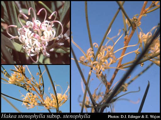
Spreading shrub, 2-5 m high, fruiting valve with red-brown wood zone 1.5-2.5 mm wide; seed covering about 3/4 valve surface. Fl. cream-white, Jun to Jul. Red sand or sandy loam, limestone. Red sandhills or coastal sand dunes, usually with spinifex.
Scientific Description
Shrubs, 2-5 m high; branchlets glabrous or hairy. Leaves alternate, 40-125 mm long, 1-8 mm wide, glabrous; lamina flat, widest around the middle, entire. Inflorescences axillary, white or cream; pedicels 5-6 mm long. Perianth 4-6 mm long, hairy; ovary glabrous; pistil 7-14 mm long, pollen presenter oblique, style glabrous. Follicles 30-45 mm long, 20-26 mm wide, corky tetrahedral projections (on external surfaces of fruit) absent; seed 17-29 mm long (including wing), 9.5-16 mm wide, the wing discontinuous, marginal, extending ± unequally down each lateral side. Flowers in June or July. Occurs in the South-west (SW) Botanical Province(s), in the Carnarvon (CAR) or Geraldton Sandplains (GS) IBRA subregion(s).
Distribution
- IBRA Regions
- Carnarvon, Geraldton Sandplains, Pilbara, Yalgoo.
- IBRA Subregions
- Cape Range, Edel, Geraldton Hills, Roebourne, Wooramel.
- IMCRA Regions
- Pilbara (nearshore).
- Local Government Areas (LGAs)
- Ashburton, Carnarvon, Exmouth, Northampton, Shark Bay, Upper Gascoyne.