- Conservation Code
- Not threatened
- Naturalised Status
- Mixed (Native in Part of Range, Naturalised Elsewhere)
- Name Status
- Current
Tall, pungent shrub or tree, 1.2-6 m high. Fl. white-cream-yellow, Jun to Sep. Red sand or loam, sandy clay over granite or laterite. Granite outcrops, rocky rises, sandstone rocky slopes.
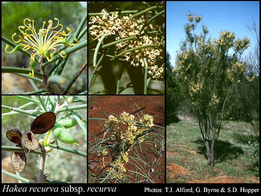
Scientific Description
Shrubs, (1-)3-4(-6) m high; branchlets glabrous or hairy. Leaves alternate, 15-130 mm long, 2-3 mm wide, glabrous; lamina terete, entire. Inflorescences axillary, white, cream or yellow; pedicels 7-12 mm long. Perianth 6-9 mm long, glabrous; ovary glabrous; pistil 6.5-11 mm long, pollen presenter oblique, style glabrous. Follicles 17-23 mm long, 8-13 mm wide, corky tetrahedral projections (on external surfaces of fruit) absent; seed 15 mm long (including wing), 0 mm wide, the wing discontinuous, marginal, extending down one lateral side only. Flowers in July, August, September or October. Occurs in the Eremaean (ER) or South-west (SW) Botanical Province(s), in the Carnarvon (CAR), Yalgoo (YAL), Murchison (MUR), Coolgardie (COO), Geraldton Sandplains (GS) or Avon Wheatbelt (AW) IBRA subregion(s).
Distribution
- IBRA Regions
- Avon Wheatbelt, Carnarvon, Coolgardie, Geraldton Sandplains, Great Victoria Desert, Murchison, Swan Coastal Plain, Yalgoo.
- IBRA Subregions
- Eastern Goldfield, Eastern Murchison, Edel, Geraldton Hills, Katanning, Lesueur Sandplain, Merredin, Perth, Shield, Southern Cross, Tallering, Western Murchison, Wooramel.
- Local Government Areas (LGAs)
- Bruce Rock, Chapman Valley, Coolgardie, Cue, Dalwallinu, Goomalling, Greater Geraldton, Kalgoorlie-Boulder, Kellerberrin, Koorda, Laverton, Leonora, Meekatharra, Menzies, Merredin, Mingenew, Moora, Mount Magnet, Mount Marshall, Mukinbudin, Murchison, Northampton, Nungarin, Perenjori, Sandstone, Shark Bay, Swan, Tammin, Trayning, Victoria Plains, Westonia, Wiluna, Wongan-Ballidu, Wyalkatchem, Yalgoo, Yilgarn.