- Reference
- Fl.Australia 17A:505 (2000)
- Conservation Code
- Not threatened
- Naturalised Status
- Native to Western Australia
- Name Status
- Current
Small tree or shrub, 2-6 m high. Fl. white-cream-yellow, May to Jul. Loam.
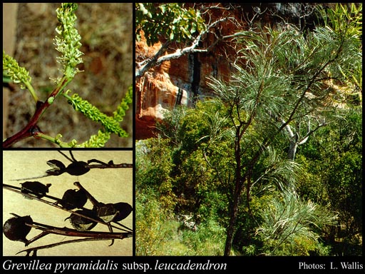
Scientific Description
Trees or Shrubs, 2-6 m high; branchlets glabrous, not glaucous. Leaves alternate, 150-300 mm long, hairy, on the adaxial or abaxial surface, the hairs straight; lamina flat, once divided, pinnately divided, divided to the midrib; lobes 50-290 mm long, 1-8 mm wide, the margins flat. Inflorescences axillary or terminal, white; pedicels 1-2 mm long. Perianth 3-6 mm long; tepals all free after flower opens, glabrous; ovary glabrous, stipitate, the stipe 2-3 mm long; pistil 5-7 mm long, white, pollen presenter conical, style glabrous. Follicles glabrous, not viscid, dehiscent, 18-23 mm long. Flowers in May, June or July. Occurs in the Northern (N) or Eremaean (ER) Botanical Province(s), in the Great Sandy Desert (GSD), Pilbara (PIL), Northern Kimberley (NK), Victoria Bonaparte (VB), Dampierland (DL) or Ord-Victoria Plains (OVP) IBRA subregion(s).
Distribution
- IBRA Regions
- Carnarvon, Central Kimberley, Dampierland, Great Sandy Desert, Northern Kimberley, Ord Victoria Plain, Pilbara, Tanami, Victoria Bonaparte.
- IBRA Subregions
- Berkeley, Cape Range, Chichester, Fitzroy Trough, Fortescue, Hamersley, Hart, Keep, McLarty, Mitchell, Mount Eliza, Pentecost, Pindanland, Purnululu, Roebourne, South Kimberley Interzone, Tanami Desert.
- IMCRA Regions
- Pilbara (nearshore), Pilbara (offshore).
- Local Government Areas (LGAs)
- Ashburton, Broome, Derby-West Kimberley, East Pilbara, Halls Creek, Karratha, Port Hedland, Wyndham-East Kimberley.