- Reference
- Trans.Roy.Soc.South Australia 97:130 (1973)
- Conservation Code
- Not threatened
- Naturalised Status
- Native to Western Australia
- Name Status
- Current
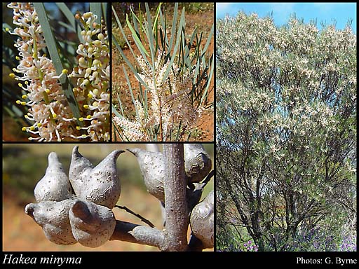
Rounded shrub, 1.2-3(-5) m high. Fl. pink-cream-white, Aug to Nov. Yellow or red sand, clay, gravel. Sandplains.
Scientific Description
Shrubs, 1.5-5(-6) m high; branchlets glabrous or hairy. Leaves alternate, (40-)80-190 mm long, (3.5-)4-7(-8) mm wide, glabrous; lamina flat, more or less the same width throughout, entire. Inflorescences axillary, cream or pink; pedicels 1-1.5 mm long. Perianth 4-4.5 mm long, glabrous; ovary glabrous; pistil (4.6-)5.5-6 mm long, pollen presenter conical, style glabrous. Follicles 15-20 mm long, 9-13 mm wide, corky tetrahedral projections (on external surfaces of fruit) absent; seed 12-21 mm long (including wing), 6-9 mm wide, the wing discontinuous, marginal, extending down one lateral side only. Flowers in August, September, October or November. Occurs in the Eremaean (ER) or South-west (SW) Botanical Province(s), in the Gascoyne (GAS), Central Ranges (CR), Yalgoo (YAL), Murchison (MUR), Great Victoria Desert (GVD), Coolgardie (COO) or Avon Wheatbelt (AW) IBRA subregion(s).
Distribution
- IBRA Regions
- Avon Wheatbelt, Central Ranges, Coolgardie, Gascoyne, Geraldton Sandplains, Great Victoria Desert, Murchison, Yalgoo.
- IBRA Subregions
- Carnegie, Central, Eastern Goldfield, Eastern Murchison, Geraldton Hills, Lesueur Sandplain, Mann-Musgrave Block, Merredin, Shield, Southern Cross, Tallering.
- Local Government Areas (LGAs)
- Bruce Rock, Coolgardie, Dalwallinu, Greater Geraldton, Kalgoorlie-Boulder, Koorda, Laverton, Leonora, Menzies, Moora, Morawa, Mount Marshall, Mukinbudin, Narembeen, Ngaanyatjarraku, Northampton, Perenjori, Sandstone, Westonia, Wiluna, Wyalkatchem, Yalgoo, Yilgarn.