- Reference
- Lam., Encycl. Suppl.4:620 (1816)
- Conservation Code
- Not threatened
- Naturalised Status
- Native to Western Australia
- Name Status
- Current
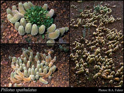
Procumbent perennial, herb, 0.01-0.25 m high. Fl. green-cream-yellow, Aug to Oct. Clay loam, sand, granite, laterite.
Scientific Description
Perennial herbs, stems several, more or less prostrate, persistently hairy or glabrescent, with verticillate hairs. Leaves present, (8-)19-100 mm long, 2-12 mm wide, glabrescent or glabrous, with nodose or verticillate hairs; basal rosette present; cauline leaves alternate. Spikes green, ovoid or cylindrical, solitary or clustered, with densely arranged flowers. Bracts 5.2-7 mm long, coloured, hairy, not awned or mucronate, with an obscure midrib. Bracteoles 4.5-5.6 mm long, colourless, hairy, awned or mucronate, with a prominent midrib. Outer tepals 8-12.5 mm long, not entire. Inner tepals 8-12 mm long, with a basal tuft of hairs on inner face. Style 1.5-2.1 mm long, curved, obliquely fixed to ovary. Distribution: South West and Eremaean Botanical Region; IBRA regions: Coolgardie.
Distribution
- IBRA Regions
- Avon Wheatbelt, Coolgardie, Esperance Plains, Geraldton Sandplains, Jarrah Forest, Mallee, Yalgoo.
- IBRA Subregions
- Eastern Goldfield, Eastern Mallee, Fitzgerald, Geraldton Hills, Katanning, Lesueur Sandplain, Mardabilla, Merredin, Northern Jarrah Forest, Southern Cross, Tallering, Western Mallee.
- Local Government Areas (LGAs)
- Albany, Beverley, Bruce Rock, Carnamah, Chapman Valley, Coolgardie, Corrigin, Cuballing, Cunderdin, Dalwallinu, Dowerin, Dumbleyung, Dundas, Esperance, Gnowangerup, Goomalling, Greater Geraldton, Jerramungup, Kellerberrin, Kent, Kondinin, Koorda, Kulin, Lake Grace, Merredin, Mingenew, Moora, Mount Marshall, Mukinbudin, Narembeen, Narrogin, Northam, Nungarin, Perenjori, Pingelly, Plantagenet, Quairading, Ravensthorpe, Tammin, Toodyay, Trayning, Victoria Plains, Wagin, Westonia, Wickepin, Wongan-Ballidu, Wyalkatchem, Yalgoo, Yilgarn, York.