- Reference
- Syn.Gen.Compos. 192 (1832)
- Conservation Code
- Not threatened
- Naturalised Status
- Native to Western Australia
- Name Status
- Current
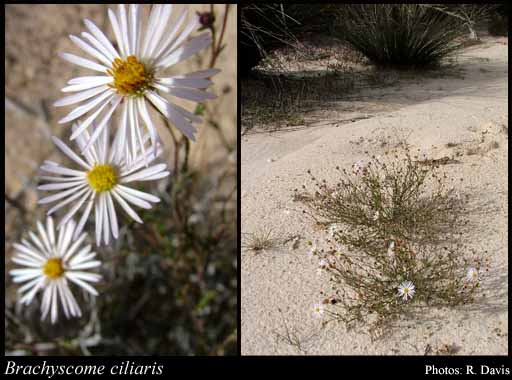
Bushy annual or perennial, herb, to 0.4 m high. Fl. white-purple, Jan to Dec. Grey sand over limestone, clay. Margins of salt pans, disturbed areas.
Distribution
- IBRA Regions
- Avon Wheatbelt, Carnarvon, Central Ranges, Coolgardie, Esperance Plains, Gascoyne, Geraldton Sandplains, Gibson Desert, Great Sandy Desert, Great Victoria Desert, Hampton, Jarrah Forest, Little Sandy Desert, Mallee, Murchison, Nullarbor, Pilbara, Warren, Yalgoo.
- IBRA Subregions
- Augustus, Cape Range, Carlisle, Carnegie, Central, Eastern Goldfield, Eastern Mallee, Eastern Murchison, Edel, Fitzgerald, Fortescue, Geraldton Hills, Hampton, Katanning, Lateritic Plain, Lesueur Sandplain, Mackay, Mann-Musgrave Block, Mardabilla, Merredin, Northern Jarrah Forest, Nullarbor Plain, Recherche, Shield, Southern Cross, Southern Jarrah Forest, Tallering, Trainor, Warren, Western Mallee, Western Murchison, Wooramel.
- IMCRA Regions
- Abrolhos Islands, Central West Coast, Eucla, Shark Bay, WA South Coast.
- Local Government Areas (LGAs)
- Albany, Beverley, Bridgetown-Greenbushes, Broomehill-Tambellup, Bruce Rock, Carnamah, Carnarvon, Chapman Valley, Coolgardie, Coorow, Corrigin, Cue, Dalwallinu, Denmark, Dumbleyung, Dundas, East Pilbara, Esperance, Exmouth, Gnowangerup, Goomalling, Greater Geraldton, Jerramungup, Kalgoorlie-Boulder, Katanning, Kent, Kondinin, Koorda, Lake Grace, Laverton, Leonora, Manjimup, Meekatharra, Menzies, Merredin, Mount Marshall, Mukinbudin, Murchison, Narrogin, Ngaanyatjarraku, Northam, Perenjori, Quairading, Ravensthorpe, Sandstone, Shark Bay, Three Springs, Trayning, Upper Gascoyne, West Arthur, Westonia, Wickepin, Wiluna, Wongan-Ballidu, Wyalkatchem, Yalgoo, Yilgarn.